Denali West Buttress Route Map: Complete Climbing Guide
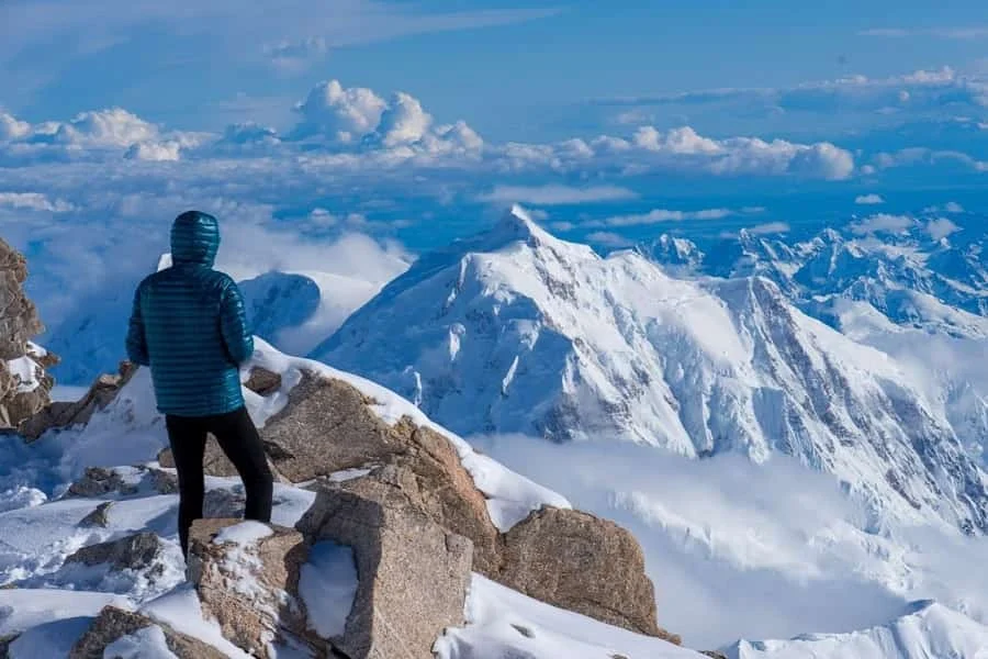
Climbing Denali is the ultimate North American mountaineering challenge. The Denali West Buttress Route Map is the most important planning tool for anyone preparing to summit Denali, the tallest peak in North America at 20,310 feet (6,190 m).
Whether you are researching your first expedition or refining logistics for an upcoming climb, understanding the Denali West Buttress Route Map will help you visualize terrain, camps, elevation gain, and key technical sections. This guide covers the full Denali climbing route map, camps, elevation profile, and expedition strategy so you can prepare with confidence.
Overview of the West Buttress Denali Route
The West Buttress Denali route is considered the standard and most frequently climbed line to the summit. Originally pioneered in 1951, it offers the best balance of safety, accessibility, and technical challenge.
When studying a Denali climbing route map, you’ll notice that the route:
- Starts on the Kahiltna Glacier (7,200 ft)
- Progresses through multiple established camps
- Climbs the West Buttress ridge
- Traverses under Denali Pass
- Finishes via the summit ridge
Although technically moderate compared to other routes on Denali, the altitude, weather, and heavy loads make it extremely demanding.
The Denali West Buttress Route helps climbers understand:
- Elevation gain between camps
- Glacier travel sections
- Fixed line locations
- High camp placement
- Summit push terrain
Denali Climbing Route Map: Camp-by-Camp Breakdown
A detailed Denali climbing route map shows the progressive camp system used for acclimatization and load carries. Below is a breakdown of the standard route.
1. Base Camp (7,200 ft) – Kahiltna Glacier
All expeditions begin after a bush plane flight from Talkeetna to the Kahiltna Glacier. Base Camp is flat but crevasse-ridden terrain. Rope travel begins immediately.
Key features on the Denali expedition route:
- Glacier travel
- Crevasse navigation
- Sled hauling begins
2. Camp 1 (7,800 ft) – Ski Hill
A short climb from Base Camp, this area is often used for load carries rather than permanent camping. The Denali standard route map highlights Ski Hill as the first steep section.
3. Camp 2 (11,000 ft)
One of the first major acclimatization stops on the Denali West Buttress Route Map. Climbers cache supplies higher before moving camp.
Terrain highlights:
- Moderate glacier slopes
- Increasing wind exposure
- Stunning views of the Kahiltna Glacier
4. Camp 3 (14,000 ft) – Basin Camp
This is the primary acclimatization camp on the Denali summit route map. Many teams spend multiple days here.
Important features:
- Medical ranger station
- Fixed lines above camp
- Launch point for carries to 16,200 ft
Most expeditions rest here to adapt to altitude before progressing.
5. Headwall & Fixed Lines (16,200 ft)
The Denali climbing route details show a steep headwall above 14,000 ft. Fixed ropes are installed for climber safety.
Expect:
- 40–50° snow and ice slopes
- Heavy packs
- Crampon and ascender use
6. High Camp (17,000 ft)
High Camp sits on the West Buttress ridge. This location is clearly marked on every Denali West Buttress Route Map.
From here:
- Weather becomes extreme
- Temperatures can drop below -30°F
- Summit push begins
Denali Summit Route Map: The Final Push
The summit section of the Denali summit route map includes several critical landmarks:
Denali Pass (18,200 ft)
A steep traverse often blasted by high winds.
Autobahn Traverse
An exposed, angled snow slope requiring careful footwork.
Football Field
A gradual incline leading toward the final summit ridge.
Summit Ridge (20,310 ft)
Narrow and exposed, but non-technical in good conditions.
The Denali West Buttress Route Map clearly illustrates the long horizontal traverse before the final summit rise — a deceptive section that feels endless at altitude.
Denali West Buttress Camps and Elevation Strategy
The Denali West Buttress camps are strategically placed for acclimatization. A typical expedition lasts 17–21 days.
Standard carry strategy:
- Carry supplies to a higher elevation
- Cache them
- Return to sleep lower
- Move camp upward
This “climb high, sleep low” method is essential on the Denali expedition route due to rapid altitude gain.
A Denali climbing route map makes it easier to visualize these elevation jumps:
- 7,200 ft to 11,000 ft
- 11,000 ft to 14,000 ft
- 14,000 ft to 17,000 ft
- 17,000 ft to summit
Denali Climbing Route Details: Terrain & Conditions
Understanding Denali climbing route details is critical before attempting the climb.
Glacier Travel
The lower half of the Denali West Buttress Route Map crosses heavily crevassed glaciers. Rope teams are mandatory.
Sled Hauling
Climbers haul 100+ lb loads using sleds up to 11,000 ft.
Fixed Lines
Installed seasonally by rangers, they protect climbers ascending the Headwall.
Extreme Weather
Denali creates its own weather systems due to its massive vertical rise. Wind chills can reach -60°F.
Why the West Buttress is the Denali Standard Route Map
There are technically harder routes on Denali, such as the Cassin Ridge. However, the West Buttress Denali route remains the most popular because:
- Lowest objective hazard
- Established camps
- Ranger support presence
- Predictable line of ascent
Any Denali standard route map will show the West Buttress as the primary guided path.
Reading a Denali Expedition Route Map Effectively
When reviewing a Denali expedition route map, focus on:
- Elevation markers
- Camp spacing
- Steep technical zones
- Summit ridge exposure
- Potential turnaround points
Professional climbers study the Denali West Buttress Route Map repeatedly before departure. It helps mentally rehearse the climb and anticipate fatigue points.
Best Time to Climb Using the Denali West Buttress Route Map
Climbing season typically runs from mid-May through early July.
Why?
- Longer daylight
- More stable weather patterns
- Established fixed lines
Early season brings colder temperatures. Late season increases crevasse danger as snow bridges weaken.
A seasonal Denali climbing route map may show slight variations depending on snowpack and crevasse patterns.
Common Mistakes When Following the Denali Climbing Route Map
- Underestimating altitude gain
- Moving too quickly between camps
- Ignoring weather forecasts
- Poor cache marking
- Inadequate fuel planning
The Denali West Buttress Route is not just a line on snow — it represents a serious high-altitude expedition requiring patience and preparation.
Physical Preparation for the Denali West Buttress Route
Climbers should train for:
- Heavy pack carries (60+ lbs)
- Sled hauling
- Sustained uphill movement
- Cold weather endurance
- Technical rope skills
Studying the Denali summit route map while training helps visualize each section of the climb.
Final Thoughts on the Denali West Buttress Route Map
The Denali West Buttress Route Map is more than a navigation tool — it is the blueprint for a successful expedition. From the Kahiltna Glacier to the exposed summit ridge, every section demands preparation, resilience, and respect for the mountain.
Understanding the Denali climbing route map, Denali West Buttress camps, and Denali climbing route details dramatically increases your chances of success. While the West Buttress Denali route is considered the standard route, it remains a serious high-altitude mountaineering challenge.
Before stepping onto the glacier, spend time studying a detailed Denali expedition route map. Know every camp, elevation gain, and technical section. Preparation turns an intimidating objective into a structured, strategic climb.
Climbing Denali is not just about reaching 20,310 feet — it’s about mastering the journey laid out on the Denali West Buttress Route.
Frequently Asked Questions (FAQs)
1. What is the Denali West Buttress Route Map?
The Denali West Buttress Route Map is a visual guide outlining the standard climbing route on Denali. It shows the Kahiltna Glacier approach, established camps (7,200 ft to 17,000 ft), the Headwall fixed lines, Denali Pass, and the final summit ridge. Most climbers use this map to plan acclimatization, cache carries, and summit strategy on the West Buttress Denali route.
2. Is the West Buttress the standard Denali summit route map?
Yes, the West Buttress is considered the Denali standard route map and is the most commonly climbed path to the summit. While there are more technical routes, the West Buttress Denali route offers the safest and most supported line with established Denali West Buttress camps and seasonal ranger presence.
3. How long does it take to climb the Denali expedition route?
Most expeditions following the Denali expedition route via the West Buttress take 17–21 days. This timeframe allows for proper acclimatization between camps shown on the Denali climbing route map, including rest days at 14,000 ft and weather contingency days at High Camp.
4. How difficult are the Denali climbing route details on the West Buttress?
The Denali climbing route details include glacier travel, sled hauling, fixed-line ascents up 40–50° slopes, and an exposed summit ridge. Technically, the West Buttress Denali route is moderate, but the altitude, extreme cold, and heavy loads make it physically and mentally demanding.
5. Where are the main Denali West Buttress camps located?
According to the Denali West Buttress Route Map, the primary camps are:
- 7,200 ft (Base Camp – Kahiltna Glacier)
- 11,000 ft Camp
- 14,000 ft Basin Camp
- 17,000 ft High Camp
These Denali West Buttress camps are positioned to support the “climb high, sleep low” acclimatization strategy.
6. Do I need a guide to follow the Denali climbing route map?
While experienced mountaineers can attempt the Denali climbing route map independently, many climbers choose guided expeditions. Guides provide structured logistics, weather decision-making, and safety oversight—especially important for navigating the Denali summit route map in extreme conditions.