Mount Elbrus Route Map: A Complete Guide to Every Climbing Route
A Mount Elbrus route map usually shows five real options: the South Route, the North Route, the lesser-used East and West Routes, and a South–North traverse that links two of them together. Most climbers only ever hear about the South Route, since it’s the one with cable cars and huts. But knowing how all four sides of the mountain differ — in distance, elevation gain, and support — makes a real difference when you’re picking dates, a guide, and a training plan. Operators are actively running trips as of mid-2026, though visa rules and travel advisories vary by nationality, so confirm your country’s current guidance before booking.
Quick Facts
- Summit: 5,642 m (West) and 5,621 m (East) — twin volcanic peaks
- Main routes: South, North, East, West, plus a South–North traverse
- South Route summit day: roughly 6–7 km one-way, ~1,800 m of elevation gain
- Entry fee: low-cost Prielbrusye National Park pass (South Route)
- Overall grade: PD (Peu Difficile) — comparable to Mont Blanc’s normal route
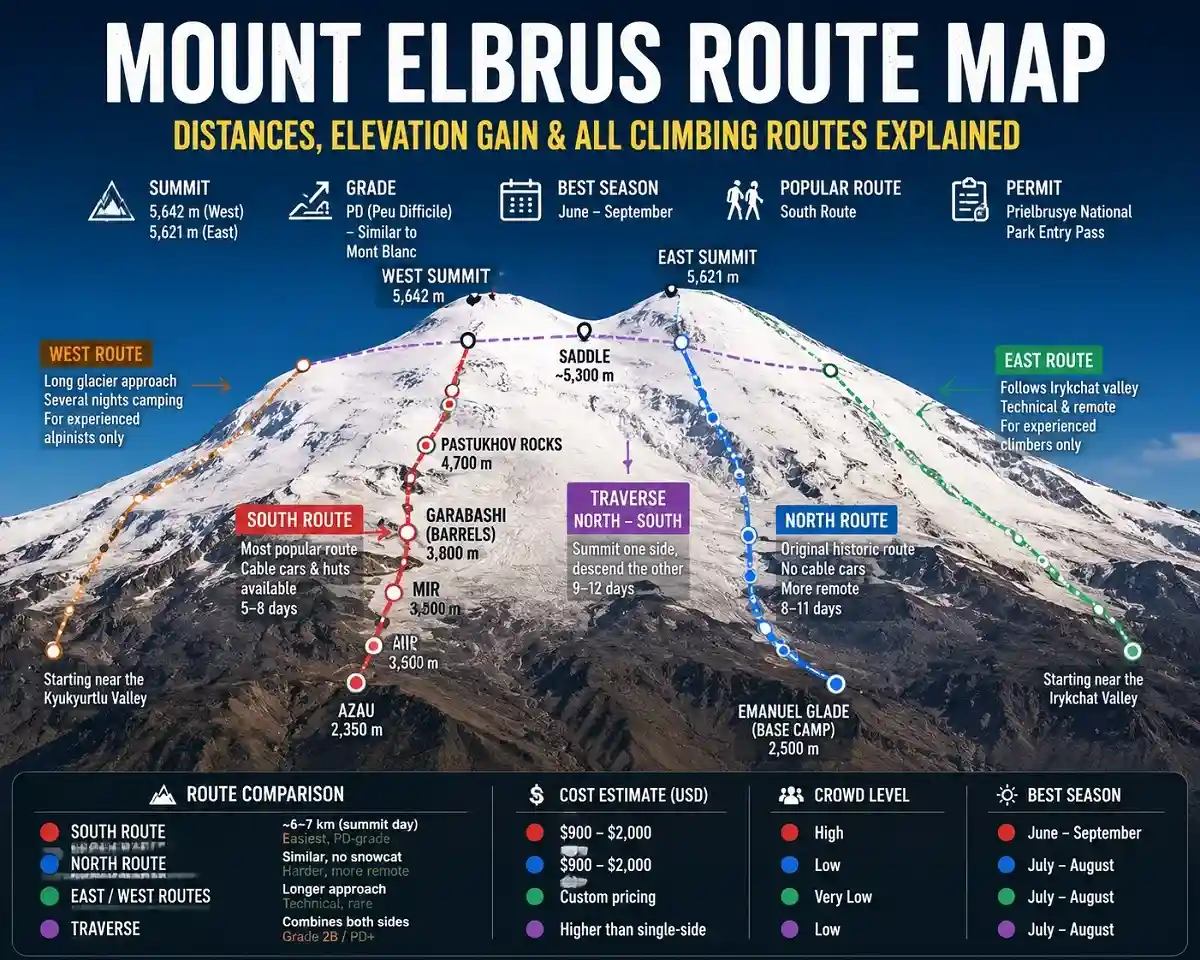
South Route: The Standard Way Up
The South Route starts in Azau and is the route almost every guided expedition uses. Three cable car sections carry you most of the way to camp; a snowcat can take you further on summit day for an extra fee, though it’s optional, not a guarantee of reaching the top.
| Stage | Elevation | Notes |
| Azau | 2,350 m | Route start, cable car base station |
| Mir | 3,450–3,500 m | Second cable car stop |
| Garabashi (“Barrels”) | 3,800–3,850 m | High camp; huts include the Barrels, Heart of Elbrus, and LeapRus |
| Pastukhov Rocks | 4,550–4,700 m | Snowcat pickup point on summit day |
| Saddle | ~5,300–5,400 m | Between the East and West summits |
| West Summit | 5,642 m | Higher of Elbrus’s twin peaks |
From Garabashi, most climbers push through Pastukhov Rocks toward the saddle, then on to the West Summit — about three hours longer than the East Summit, but 21 metres higher. Some groups decide which peak to aim for only once they’re above 5,100 m, based on time and weather.
Suggested Package
Summit Day Timeline (South Route)
Exact timings shift with weather and group pace, but a typical South Route summit day looks like this:
| Stage | Typical Time | Elevation |
| Departure | 1:00–4:00 a.m. | 3,800 m |
| Pastukhov Rocks | Pre-dawn | 4,700 m |
| Saddle | Mid-morning | ~5,300 m |
| Summit | ~10 a.m.–1 p.m. | 5,642 m |
| Return to Garabashi | Afternoon | 3,800 m |
North Route: The Original, Wilder Line
This was the line used on Elbrus’s first recorded ascent, in 1829, and it still feels that way — no hotels, no cable cars, no snowcats. Climbers drive roughly 90 km by 4×4 from Kislovodsk to the Emanuel Glade base camp; from there the route is largely self-supported, though some operators offer porter support for an extra cost.
| Stage | Elevation | Notes |
| Emanuel Glade (Base Camp) | 2,500 m | Reached by 4×4 from Kislovodsk, ~90 km |
| North Hut (High Camp) | ~3,800 m | Gear mostly self-carried; some operators offer porter support |
| Lenz Rocks | ~5,000 m | Key acclimatization point |
| Saddle | ~5,300 m | Rest stop before the final push |
| East Summit | 5,621 m | Most North Route climbers summit here |
Most North Route climbers aim for the East Summit (5,621 m) rather than the West, since it’s the more direct line from Lenz Rocks. Expect fewer people, more physical effort, and a longer overall itinerary — typically 8–11 days versus 5–8 on the South Route.
East and West Routes: For Specialists
The East Route follows the Irykchat valley toward a ridge below the East Summit. The West Route crosses the Kyukyurtlu glacier with several nights of glacier camping. Both see only a handful of ascents a year, have no permanent huts, and suit alpinists with real glacier experience only.
The Traverse: Climbing One Side, Descending the Other
Also called the “Elbrus Cross,” a traverse means summiting from one side and descending the opposite one — usually North to South. It’s rated around grade 2B (UIAA PD+), involves glacier travel with a loaded pack (roughly 12 kg), and typically runs 9–12 days: approach and acclimatize on the north side, push for the summit, then descend through the South Route’s huts and cable cars.
Route Comparison: Distance and Difficulty
| Route | Summit-Day Distance | Typical Duration | Difficulty |
| South Route | ~6–7 km one-way | 5–8 days | Easiest, PD-grade |
| North Route | Similar, no snowcat shortcut | 8–11 days | Harder, more remote |
| East / West Routes | Longer approach | Variable | Technical, rare |
| Traverse | Combines both sides | 9–12 days | Grade 2B / PD+ |
Route Comparison: Cost, Crowds, and Season
| Route | Approx. Cost (USD) | Crowd Level | Best Season |
| South Route | $900–$2,000 | Highest | June–September |
| North Route | Similar range | Low | July–August |
| East / West Routes | Custom pricing | Very low | July–August |
| Traverse | Higher than single-side | Low | July–August |
Success-rate figures often quoted for Elbrus (roughly 80–90% on the South Route, around 50% on the North) come from operator and guide-reported data rather than one official registry, so treat them as general estimates that shift with weather and group experience each season.
Permits, Fees, and Where You’ll Sleep
The standard South Route needs only a low-cost Prielbrusye National Park entry pass. The North, East, and West Routes sit farther from any cable car infrastructure, and permit needs there depend on the exact valley, so confirm current requirements with your operator.
South Route climbers usually sleep at Garabashi — in the Barrels, the Heart of Elbrus hotel, or the LeapRus hut. North Route climbers stay in tents or a small hut at Emanuel Glade, with hotels available in Terskol, Cheget, or Azau before and after.
Weather and Best Season by Route
The South Route is the most sheltered from bad weather, since huts and cable cars offer a quick retreat. The North, East, and West Routes carry more exposure regardless of season. July and August offer the most stable conditions everywhere; June and September still work on the South Route but narrow the safe window up north.
Which Route Should You Choose?
- First-time high-altitude climber → South Route, for infrastructure and the highest success rate.
- Experienced hiker wanting a quieter mountain → North Route, if you can handle a longer, self-supported trip.
- Technical alpinist chasing something rare → East or West Route, with a specialist guide.
- Want to see both sides of Elbrus, or training for the Seven Summits → the traverse or South Route first.
Safety and Emergency Access
Crevasses, whiteouts, and high winds are real hazards on every route; a rope is recommended on the glaciated sections of the North, East, West, and traverse lines. The South Route has the fastest emergency response, since snowcats and radio contact reach injured climbers quickly. Response is slower and less certain on the remoter routes — one more reason they’re not suited to first-time climbers.
Common Mistakes to Avoid
- Picking the North Route as a first high-altitude climb without prior self-supported trekking experience.
- Booking without a weather-reserve day; skipped acclimatization is the leading cause of failed summit attempts.
- Booking a traverse or an East/West route without any prior glacier travel or rope-team experience.
Pro Tips
- On the South Route, using the snowcat on summit day meaningfully cuts fatigue before the final push.
- For the North Route, budget extra days for the unpaved 90 km approach road, which can be slow in poor weather.
Frequently Asked Questions
1. Which Mount Elbrus route is easiest?
The South Route, thanks to cable cars, snowcats, and established huts along the way.
2. Which route has the shortest summit day?
The South Route, since the snowcat option cuts several kilometres and hours off the walk.
3. Can beginners climb the North Route?
It’s not recommended; it’s self-supported, longer, and better suited to experienced climbers.
4. What’s the difference between the East and West summits?
The West Summit (5,642 m) is the higher peak; the East Summit (5,621 m) is reached faster from the North Route.
5. What is the Elbrus traverse?
A route that climbs one side of the mountain and descends the other, usually North to South, over 9–12 days.
6. Do I need glacier experience for any Elbrus route?
For the traverse and the East/West Routes, yes. The standard South Route needs less technical background.
7. Which route has the best rescue access?
The South Route, where snowcats and radio contact allow the fastest response times.
8. Is the North Route cheaper than the South Route?
Not necessarily — longer days and full-carry logistics often offset the lack of cable car fees.
9. Which route has the highest summit success rate?
The South Route, generally cited around 80–90%, compared with roughly 50% on the North Route.
Final Word
A Mount Elbrus route map isn’t just South versus North — it’s a choice between comfort and solitude, and between a well-marked ascent and a wilder one. Pick the South Route for the safest, most supported climb; the North Route for a quieter, tougher one; the East or West Route only if you’re an experienced alpinist; and the traverse if you want to experience both sides of the mountain on a single Elbrus ascent.
Suggested Package