Aconcagua Climbing Expedition Route Map
An accurate Aconcagua route map is the first thing you need before flights, gear or training, because the route you pick decides your itinerary length, gear list and technical skill requirement. Aconcagua is the highest mountain in the Americas at 6,961 metres (22,838 feet), inside Mendoza Province’s Aconcagua Provincial Park in Argentina. Every one of Aconcagua’s climbing routes — Normal, Polish Glacier Traverse or Polish Glacier Direct — changes what your expedition actually looks like on the ground, making route selection one of the most important decisions for a successful Aconcagua Climbing expedition.
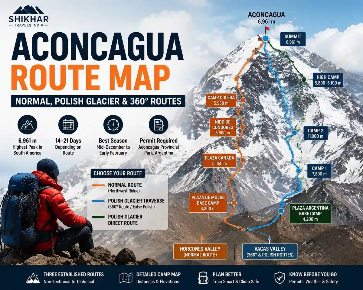
Quick Answer
Aconcagua has three established routes. The Normal Route (Northwest Ridge) starts at Plaza de Mulas and needs no rope or ice-climbing skills. The Polish Glacier Traverse — also called the False Polish or 360° Route — starts at Plaza Argentina in the Vacas Valley and is also non-technical. The Polish Glacier Direct Route climbs the glacier itself, with sections up to 55–60°, and suits experienced ice climbers only.
Where Aconcagua Sits, and Why the Approach Valley Matters
Aconcagua rises in the Andes near the Argentina–Chile border, about a five-hour drive from Mendoza city — the highest peak outside Asia and one of the Seven Summits. The Normal Route has earned it a reputation as one of the world’s highest non-technical mountaineering objectives — though ‘non-technical’ refers only to climbing grade, not to the altitude, wind and cold that make every route here a serious undertaking. Swiss guide Matthias Zurbriggen made the first recorded ascent on 14 January 1897.
Aconcagua’s Three Climbing Routes
1. Normal Route (Northwest Ridge / Horcones Valley)
The standard route, and the one most guided expeditions run. You walk in through the Horcones Valley to Confluencia, then to Plaza de Mulas base camp, before three high camps — Plaza Canada, Nido de Cóndores and Cólera (also called Berlín; called Cólera throughout this guide) — set up the summit push. There’s no roped climbing, but Aconcagua Provincial Park rules require double mountaineering boots, crampons and an ice axe above 4,300 metres, on every route.
2. Polish Glacier Traverse (False Polish / 360° Route)
This trekking route approaches from the east through the Vacas Valley — Punta de Vacas, Pampa de Leñas, Casa de Piedra — to Plaza Argentina base camp. It shares its first two high camps with the technical Polish Glacier Direct route, then traverses north below the glacier to join Camp Cólera for the summit attempt. It’s non-technical, quieter than the Horcones side, and becomes the 360° Route when paired with a Horcones descent — a full circuit of the mountain.
3. Polish Glacier Direct Route
Named after the 1934 Polish expedition that first climbed it, this route stays on the glacier, with a high camp near its base (roughly 5,860–6,100m) and a summit day gaining over 1,000 metres on snow and ice, including a gully around 55–60°. Fixed ropes and real glacier experience are non-negotiable. Because of shifting ice and crevasse conditions in recent seasons, this is now considered a route for experienced technical climbers only — and the park’s Rescue Patrol does not operate on it.
| Route | Approach Valley | Base Camp | Technical Grade | Typical Duration |
|---|---|---|---|---|
| Normal Route | Horcones | Plaza de Mulas (~4,300m) | Non-technical | 14–18 days |
| Polish Glacier Traverse (360°) | Vacas | Plaza Argentina (~4,200m) | Non-technical | 16–20 days |
| Polish Glacier Direct | Vacas | Plaza Argentina (~4,200m) | Technical — ice/glacier | 18–21 days |
Aconcagua Normal Route Map: Camp-by-Camp Distances and Elevations
Distances and elevations below are trail estimates from multiple guided itineraries and GPS-tracked routes; operators and surveys report slightly different numbers for the same points, so treat this as a planning reference and confirm exact figures with your operator or the park rangers.
| Point | Elevation | Distance | Approx. Time |
|---|---|---|---|
| Horcones (start) | ~2,950m | — | — |
| Confluencia | ~3,300–3,400m | ~7 km | 3–4 hrs |
| Plaza de Mulas (Base Camp) | ~4,260–4,390m | ~18–22 km | 7–10 hrs |
| Camp 1 — Plaza Canada | ~4,900–5,050m | ~5 km | 4–5 hrs |
| Camp 2 — Nido de Cóndores | ~5,350–5,560m | ~4 km | 4–5 hrs |
| Camp 3 — Cólera | ~5,850–6,000m | ~2–3 km | 3–4 hrs |
| Summit | 6,961m | ~3.5 km | 7–10 hrs (summit day) |
Summit Day Timeline
Summit day covers roughly 3.5 km and 900–1,000 metres of gain from Cólera camp, and typically runs 12–15 hours door to door. Exact timing varies by operator; a representative schedule looks like this:
| Time | Stage |
|---|---|
| 02:00–03:00 | Wake, hydrate, gear up |
| 03:30–05:00 | Depart Cólera camp |
| ~05:00–07:00 | Reach Independencia refuge (~6,400m) |
| ~07:00–09:00 | Cross the Gran Acarreo scree traverse |
| ~09:00–11:00 | Climb the Canaleta (35–40° scree/snow headwall) |
| ~11:00–13:00 | Summit, then begin the descent |
| 13:30–19:00 | Return to Cólera camp |
Guides typically set an early-afternoon turnaround time regardless of distance to the summit — descending safely matters more than reaching the top.
Aconcagua Permit Fees and Process (2025/26 Season)
Permits are issued by Mendoza province and must be bought in person in Mendoza city, or through a registered local operator, before you enter the park. Confirmed 2025/26 season rates were:
| Route | Assisted Permit | Unassisted Permit |
|---|---|---|
| Normal Route (Horcones) | $1,170 | $1,640 |
| 360° / Polish Traverse (Vacas) | $1,450 | $2,000 |
“Assisted” means you’ve booked at least basic local services (mules, water, bathrooms) through an authorized operator; “unassisted” means none. Permits cover up to 20 days in the park. Mendoza had not published 2026/27 season rates at the time of writing, so confirm current figures with the park office before booking.
- Apply at the Department of Renewable Natural Resources (San Martín Ave 1143, Mendoza) or via an authorized operator; official-season hours run roughly Mon–Fri 8am–6pm, weekends/holidays 9am–1pm.
- Proof of rescue and medical evacuation insurance, covering helicopter evacuation to at least 6,000–7,000m, must be shown before the permit is issued.
- Permits are non-refundable and non-extendable — a missed window means buying a new one at the current rate.
Safety, Success Rates and Environmental Rules
Aconcagua’s summit success rate is commonly estimated at 30–40%, though this varies significantly by season, weather, route and whether climbers are guided. Altitude illness — AMS, and more rarely HAPE or HACE — is the leading cause of turnarounds and evacuations, ahead of any technical hazard on the standard routes. At the entry checkpoint, rangers issue a numbered trash bag and an individual human-waste bag, mandatory on every route and checked at exit. The park’s Rescue Patrol is confirmed to operate on the Normal Route; the Polish Glacier and South Wall routes get radio monitoring but no guaranteed patrol response.
Common Mistakes Climbers Make on Aconcagua
- Rushing Plaza de Mulas to Nido de Cóndores without a carry-and-sleep-low rotation — the top cause of failed summit bids.
- Underestimating wind: summit-ridge gusts regularly exceed 100 km/h and have turned back well-acclimatized teams.
- Choosing the Polish Glacier Direct route without prior glacier or ice-climbing experience.
Pro Tips for a Safer Aconcagua Climb
- Choose the Vacas Valley approach (Polish Traverse) for fewer crowds and a longer acclimatization walk-in.
- Test your full high-altitude kit — boots, mitts, goggles — on a lower peak before you fly to Mendoza.
- Carry a satellite communicator; cell coverage disappears above Confluencia on most routes.
Frequently Asked Questions
What is Aconcagua’s elevation?
6,961 metres (22,838 ft) is the commonly cited figure; Argentina’s official survey lists 6,959 metres.
What is the best route to climb Aconcagua for beginners?
The Normal Route — no rope work, just solid fitness and prior altitude experience.
Is the Polish Glacier Direct Route technical?
Yes, with sections up to 55–60° needing fixed ropes and real glacier skills.
What does a typical Aconcagua Normal Route itinerary look like?
Most guided trips run 14–18 days, including acclimatization and weather-buffer days.
What exactly is the 360° Route?
A route up the Vacas Valley and down Horcones (or the reverse) — a full loop of the mountain.
How much is the Aconcagua permit in the 2025/26 season?
$1,170 assisted or $1,640 unassisted on the Normal Route; confirm current rates before booking.
Can I climb Aconcagua without a guide?
Yes, with the same permit and mandatory insurance, but more self-rescue responsibility off the Normal Route.
Which Aconcagua route is cheapest?
The Normal Route’s permit is lower than the Vacas/360° permit, though logistics costs vary by operator.
Which Aconcagua route is safest?
The Normal Route, since it’s the only one with confirmed Rescue Patrol coverage.
What is the best season to climb Aconcagua?
December to February, inside the mid-November to mid-March park season.
Is mobile signal available on the mountain?
Coverage is unreliable above Confluencia on most routes; carry a satellite communicator.
Can I change routes after getting my permit?
Generally you’ll need a new or amended permit — check with the park office before committing.
What gear is mandatory above 4,300 metres?
Double mountaineering boots, crampons and an ice axe, by park rule, on every route.
Is Aconcagua permit money refundable if I don’t summit?
No — fees are non-refundable and non-extendable once purchased.
What is Aconcagua’s summit success rate?
Commonly estimated at 30–40%, varying by season, weather, route and guiding.
Final Word: Your Aconcagua Route Map Summed Up
Aconcagua rewards planning over raw strength. The Normal Route gets you to the summit without a rope in hand; the Polish Glacier Traverse offers a quieter valley on the same non-technical terms; the Polish Glacier Direct route is a genuine ice climb for climbers who already have that background. Whichever ascent route you choose, use this Aconcagua route map to lock in your permit and insurance early, and confirm every fee and date with Mendoza’s park authorities before you commit.